


Reis Twp. Voting District, Polk County, Minnesota
About
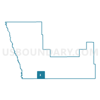
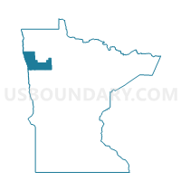
Outline

Summary
| Unique Area Identifier | 603682 |
| Name | Reis Twp. Voting District |
| County | Polk County |
| State | Minnesota |
| Area (square miles) | 34.05 |
| Land Area (square miles) | 34.05 |
| Water Area (square miles) | 0.00 |
| % of Land Area | 100.00 |
| % of Water Area | 0.00 |
| Latitude of the Internal Point | 47.54258130 |
| Longtitude of the Internal Point | -96.51487540 |
Maps

Graphs
Select a template below for downloading or customizing gragh for Reis Twp. Voting District, Polk County, Minnesota


Neighbors
Neighoring Voting District (by Name) Neighboring Voting District on the Map
- Beltrami Voting District, Polk County, MN
- Good Hope Twp. Voting District, Norman County, MN
- Hammond Twp. Voting District, Polk County, MN
- Liberty Twp. Voting District, Polk County, MN
- Lockhart Twp. Voting District, Norman County, MN
- Onstad Twp. Voting District, Polk County, MN
- Russia Twp. Voting District, Polk County, MN
- Scandia Twp. Voting District, Polk County, MN
- Spring Creek Twp. Voting District, Norman County, MN
Top 10 Neighboring County Subdivision (by Population) Neighboring County Subdivision on the Map
- Liberty township, Polk County, MN (108)
- Beltrami city, Polk County, MN (107)
- Spring Creek township, Norman County, MN (81)
- Reis township, Polk County, MN (79)
- Scandia township, Polk County, MN (74)
- Onstad township, Polk County, MN (71)
- Lockhart township, Norman County, MN (50)
- Hammond township, Polk County, MN (44)
- Good Hope township, Norman County, MN (43)
- Russia township, Polk County, MN (27)
Top 10 Neighboring Place (by Population) Neighboring Place on the Map
Top 10 Neighboring Unified School District (by Population) Neighboring Unified School District on the Map
- Crookston Public School District, MN (9,712)
- Fertile-Beltrami School District, MN (2,829)
- Ada-Borup Public School District, MN (2,661)
Top 10 Neighboring State Legislative District Lower Chamber (by Population) Neighboring State Legislative District Lower Chamber on the Map
Top 10 Neighboring State Legislative District Upper Chamber (by Population) Neighboring State Legislative District Upper Chamber on the Map
Top 10 Neighboring 111th Congressional District (by Population) Neighboring 111th Congressional District on the Map
Top 10 Neighboring Census Tract (by Population) Neighboring Census Tract on the Map
- Census Tract 205, Polk County, MN (2,778)
- Census Tract 208, Polk County, MN (2,206)
- Census Tract 9602, Norman County, MN (1,901)